Saba Khan is a visual artist and Associate Lecturer at Chelsea College of Art, London. Her multimedia works traffics into the language of memorial, monument and expeditions around water bodies and infrastructures. This blog post chronicles an expedition (and the resultant exhibition, The Tide Country) in which she led a group of female Pakistani artists along the Indus River, documenting visually the ecological and societal repercussions of utilising the river to irrigate agricultural land by building dams. You can follow Saba on Instagram.
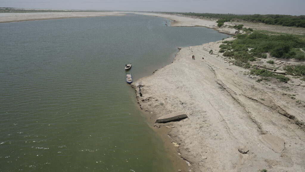
We walk onto the banks of River Indus, a long 2000-mile water body that cuts across the length of Pakistan after flowing through China and India. This river has experienced dynamic transformations during the time of the British Empire when it became a site for damming and diverting water for agricultural production. Pakistan’s post-colonial economic development was based around several large-scale infrastructure projects. The river has subsequently witnessed a number of hydro-power dam projects and barrages since the 1960s and then again in 2018. This main water artery has also been an area of study for various empires, scholars, and explorers for centuries.
Our Ladies Club Expedition and Uniform
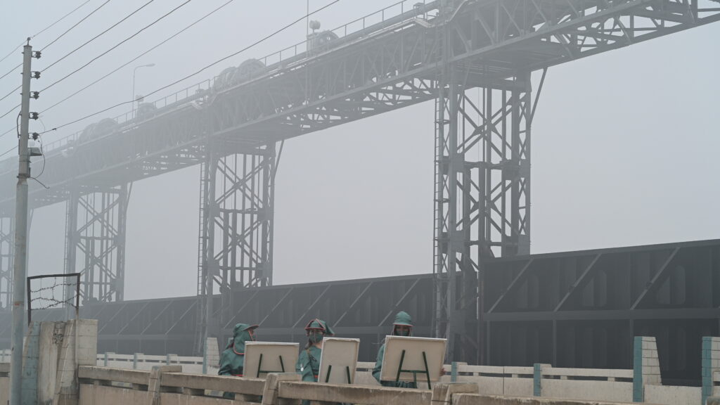
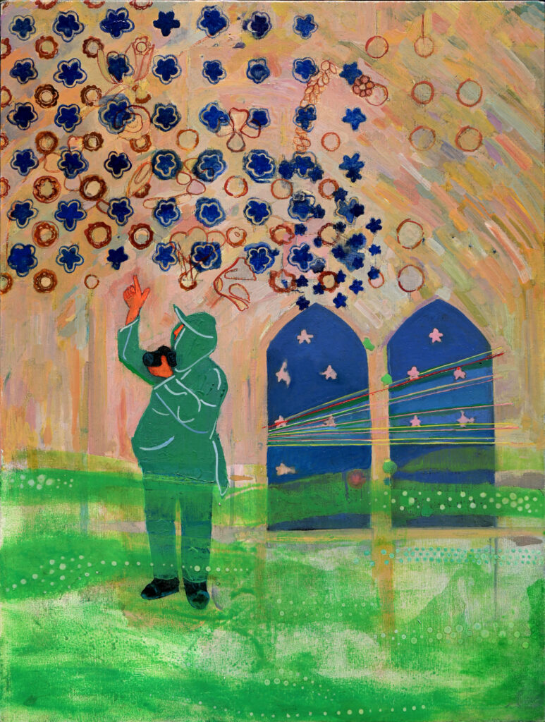
Since 2019, I have led several expeditions along the river with women artists to see the social and environmental impact of both colonial and modern barrages and dams, and their effect on river communities and historical sites. For our trips, we all wear a uniform designed to look like a hybrid of French designer Pierre Cardin’s retro-futurist designs and the Girl Guides’ geeky aesthetic with badges. Pierre Cardin was the official designer of Pakistan International Airlines in the 1960s when Pakistan was on its pathway of modernity. The Girl Guides were chosen because it was also a colonial project to train children and women to prepare for the harsh and unpredictable environment of the colonies. In Pakistan, a country where women are rarely seen in public, our uniforms were a shield and a protective layer asserting authority, and blended with the Pakistani military uniforms who guarded these spaces.
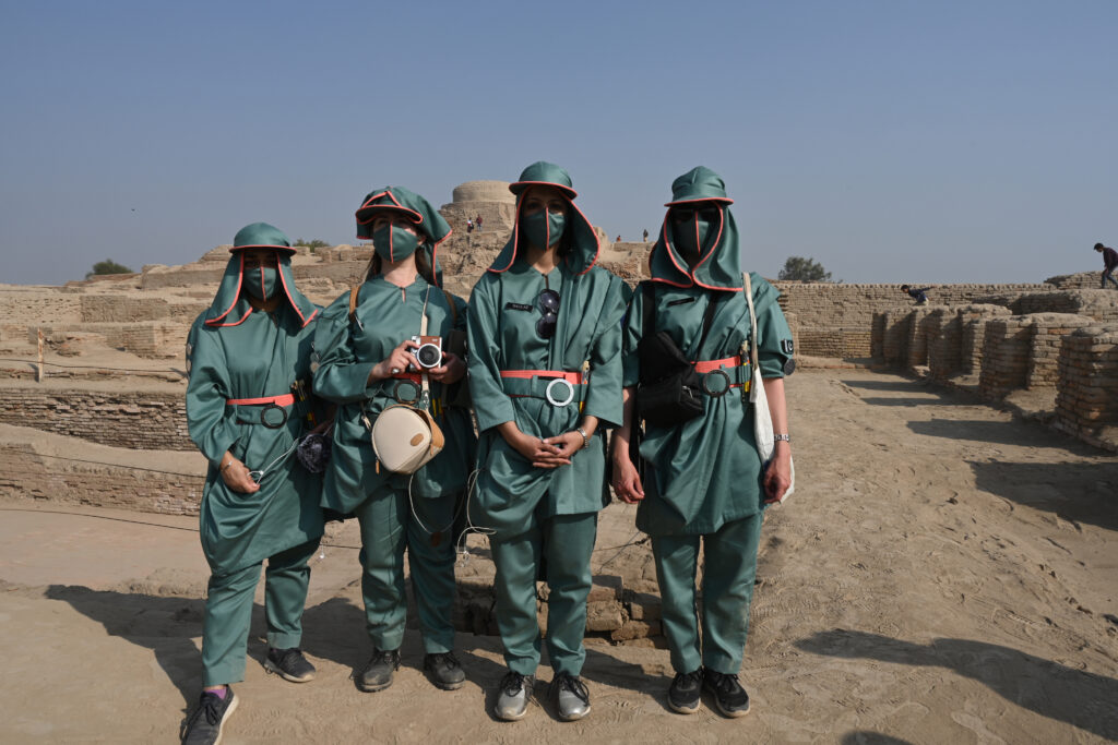
Our imaginary, satirical collective of artists in uniform was called the ‘The Pak Khawateen Painting Club’ or PKPC, loosely translated as the “good Pakistani girls’ club”. We started in the middle of the country and wound ourselves downwards, crossing over seven barrages on the River Indus.
In terms of water bodies and infrastructures, Pakistan can be divided into three zones: the lowlands near Indus River estuary, segmented by the barrages; the midlands, with numerous hydropower dams; and the highlands, boasting over 7,000 glaciers. The glaciers – the water source for the Indus and other rivers in South Asia – form part of one of the largest ice and water reserves in the world.
Pakistan frequently confronts extreme climate-related disasters such as floods, droughts, water shortages, melting glaciers, as well as electricity shortages and food shortages.
Exploring the Delta Dust Bowl
The end point of the River Indus is the decaying delta of Keti Bandar, which has soil so saline with sea water intrusion that nothing grows here. It was formerly a port town infiltrated by both British and Portuguese merchant ships, and later occupied by the British Empire where it housed the East India company’s factories. The port was called Lahri Bandar and connected the sea to the Mughal stronghold of Lahore. It was a route for commerce with links to the Silk Route.
Pakistan : An Ambitious Agrarian Frontier
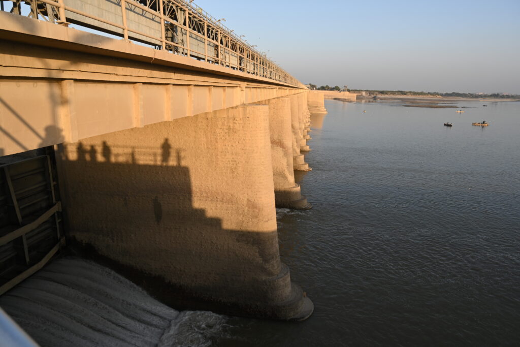
The area, which is now Pakistan was ‘the new agrarian frontier’ for the British Empire. A complex irrigation system was laid out as a quest to tame nature and turn it into a productive machine for food production. One of the first structures was the Sukkur Barrage built in 1920. To cover its extraneous cost and make the area ‘productive’ a massive relocation of castes, ethnic groups and private property was undertaken by the British. In the book, Blood and Water: The Indus River Basin in Modern History, historian David Gilmartin explains that the engineering of hydro monuments led to acute disparities and an increase in feudal lords.
Today, the River Indus is a site heavily fragmented and militarised with mega hydropower dams and barrages. Each structure blocking the river stops the alluvial soil from flowing south and creates desert-like spaces in lower riparian landscapes.
Meeting the Women Farmers
At the start of our journey, we meet the women farmers/peasants who till their own small acreage of land situated on the ‘Laar’ (lower belt near the Arabian Sea). Cornered between the Arabian sea and the Indian border, these last villages at the end of the canal are situated downstream. The elder matriarch of the family, Rehanna Bibi who is 75 years, tells us how her father and grandfather both had pastoral lifestyles and would cross over to Rajasthan prior to Partition for grazing. She and other farmers recall how water supply was not a problem twenty years ago but is now reduced to a trickle in their canals. There is barely any fresh water available to drink.
The Sukkur Barrage, as environmental historian, Daniel Haines, puts it: “The terms “modernity”, “progress” and “development” in the Imperial and Pakistani lexicon have been repeatedly used as a ruse to continue building hydropower projects, particularly in the Lower Indus, which has historically been considered notorious for backwardness and a regressive socio-economic order characterised by feudalism and irregularity of water provision.”
Shrinking Delta, Fish and Water Supplies
In the delta of the tiny town of Keti Bandar, we meet the head of the fisherman’s union, Gulab Shah. He explains to me the practices of traditional farming. As the river heaved out the fertile alluvial soil, the red rice seeds were scattered on mud plains. This early agrarian method is explained in a book, Against the Grain’ by the late political scientist, James C. Scott. The technique was advantageous as small independent communities could plant crops without relying on a lot of labour. In recent years, without the influx of the alluvial soil, barricaded by numerous barrages, reservoirs and dams, the town has been deprived of agriculture and turned into a dust bowl of salinity, decay and poverty.
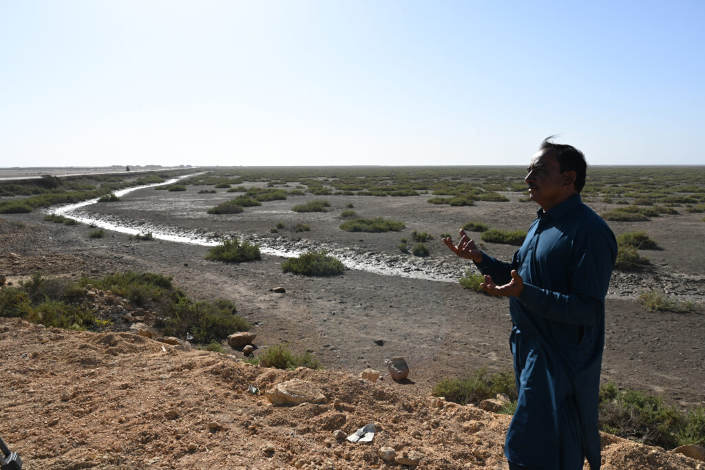
The fishermen are now in competition with deep sea trawlers in the ocean who take away millions of dollars of fish (Source: Pakistan Bureau of Statistics). Shah explains how the lack of fresh water has shrunk the natural habitats of shrimp, palla fish and Indus dolphins. It also has led to an acute shortage of drinking water; the town has had to bring in trucks of blue jerry cans filled with water and each household now spends 4,000 Pakistani rupees (equivalent to 30 US Dollars) on drinking water alone each week.
Our journey continues on a wooden boat. We pass several boats of men and children, all of whom were going to and from the sea on wooden boats powered by polluting oil engines. Our guide explains to me that this area is called Kharo Chan (now a saline delta), but it was once fertile land. The word chan means to sift, as the river has been sifted into many branches. The grey waters of the Indus lap next to the turquoise waters of the sea intruding over the land. The barren sand dunes are habitats to several bird species, but no vegetation grows here. A rickety and broken wooden bridge meant to be an esplanade over the mangroves, creeks and shakes under our feet. On our way back, we were stopped by a Maritime Security Guard for exploring the delta without their permission.
The Big Dam Era of the 1960s
The delta no longer receives the abundance of alluvial soil as it once did, and it is being further dried up by seven barrages and several mega dams – and many more are still under construction. The soil is being deposited at the Tarbela Dam, which is one of the largest hydropower dams in the world. After Partition between India and Pakistan, India turned off the water of the Lahore canal in the first year of independence. Because of the newly marked borders, Pakistan lost control over its waters, and it had become a point of contention for the Pakistani government as India continued to build and block waters on the borders. Being upstream, it has an advantage over Pakistan. Water became a contested issue between the two countries and was a point of continued paranoia and mistrust. In the 1960s, a compromise water deal Indus Water Treaty between the two countries was reached, which led to the construction of Tarbela Dam and Mangla Dam as compensation.
The Endangered Indus River Dolphin
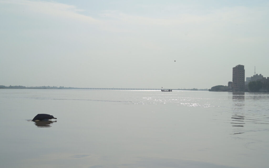
We were fortunate to witness a sighting of a Indus River Dolphin. The young Karakorum mountains in the north of Pakistan are still growing and rubbing against the two tectonic plates causing many landslides and earthquakes. The mud and sand have settled in the reservoir of Tarbela Dam which has lost its storage capacity by one third since it was constructed. Due to the continued erosion from the mountains, the Indus is a very muddy river, forcing the dolphins to adapt to their last remaining environment. The Indus River dolphin is also one of the world’s most endangered freshwater dolphins. It is trapped between two barrages and cannot swim further north, as it used to. There are only a few hundred now left as many of them become trapped in shallow canals and cannot swim back to the deep river waters. Their decreasing population is an important indicator to the health of the river.
A Solar Future
Towards the end of our trip we drive through the Kirthar National Park, a remote rugged stretch of land in the south of the country with rich biodiversity. Here, we see a nomadic herder taking a break from his goats with a solar panel connected to his mobile phone for charging. All along the way throughout our expedition I noticed solar panels as a ubiquitous technology in mud huts, homes, and shops. A recent 2023 national census claimed that 7% of Pakistani’s (comprising 20 million people) have chosen to go off grid and are now using solar energy. This is especially the case in rural areas.
We see these people organising this themselves as they cannot wait to rely on the government for a continuous, reliable electric power supply. As solar panels become more readily available in the country, and Pakistan spirals into debt from borrowing and adding more mega dams, one asks why there was a need to build over and break apart the rivers.
The Tide Country
The expedition resulted in a multimedia project The Tide Country which was presented at the Sharjah Biennial 15 Thinking Historically in the Present, in 2023. The exhibition brings together over 150 artists and collectives, and was conceived by the late Nigerian curator and art critic, Okwui Enwezor and curated by Hoor Al Qasimi. My project was funded by Sharjah Art Foundation and Graham Foundation.
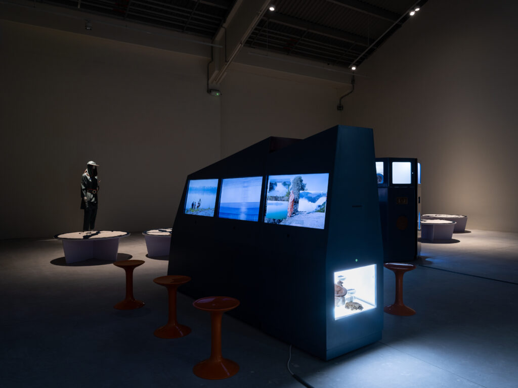
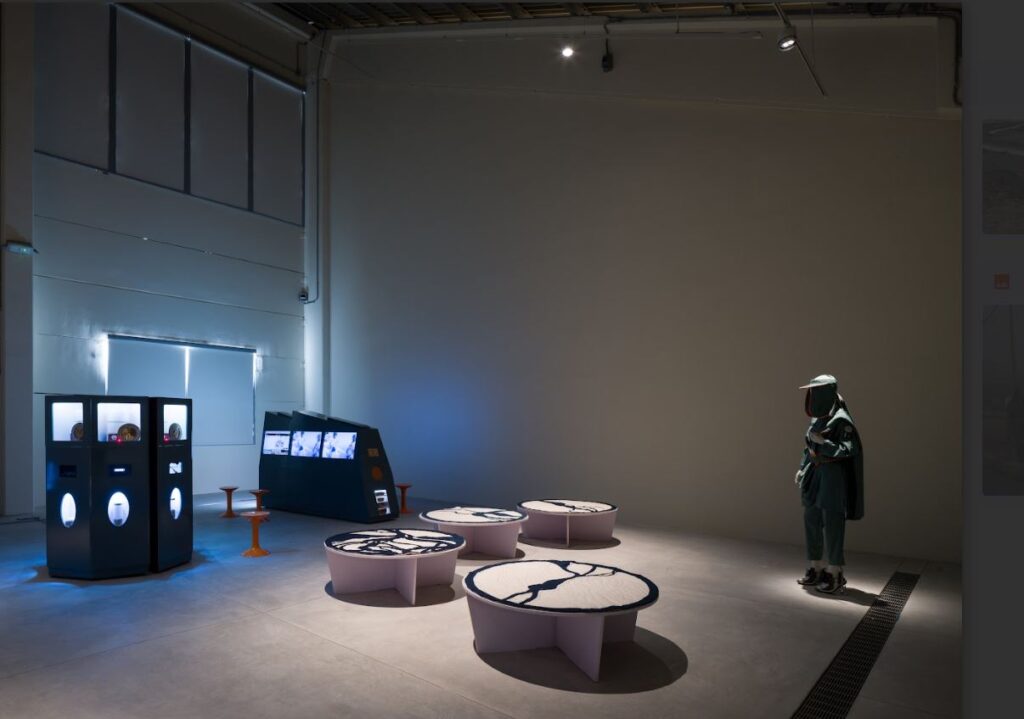
Inspired by the intricate machinery of the River Indus barrages, we developed The Tide Country (2022) as a powerful commentary on the ecological fallout from the river’s fragmentation and exploitation. Using mixed media (PVC sheets, TV screens, tablets, glass bottles, rocks, bowl, LED lights, paint and metal) the installation’s design mirrors the imposing forms of these machines, embodying the stark, industrial forces at play. Nestled within each mechanical structure are zines that share our findings — an unflinching critique of capitalist colonialism. These texts deepen the work’s message, urging reflection on the devastating impacts of environmental control and the urgent need for a more sustainable, equitable relationship with nature.
The views and opinions expressed in this blog post are solely those of the blog post author. These views and opinions do not necessarily represent those of Global Souths Hub and/or any/all contributors to this site.
About Saba Khan
Saba Khan is a visual artist whose multimedia works traffic in the language of memorial, monument and expeditions around water bodies. From miniature dioramas of a bureaucrat’s boring office, flashing LED of retro sci-fi machines seen at power stations to indigo textile banners honouring peasant revolts, she balances grandeur, artifice and satire in order to explore the cracks in the structures. Saba lives and works in London and Lahore.
She founded an artist-run-space Murree Museum Artist Residency, the collective Pak Khawateen Painting Club, taught at the National College of Arts, Lahore and is now an Associate Lecturer at Associate Lecturer at Chelsea College of Art. She is interested in water bodies restructured through large scale infrastructure and bureaucratic decision making.
